AOTEA ROAMERS
 

WAIAU PASS ROUTE

(NELSON LAKES TO LEWIS PASS)


Diverse landscapes with pristine alpine lakes aplenty…

Merging half of two separate walks by traversing the Waiau Pass, the Waiau pass route is a journey will ever-changing landscapes showing of a wide range of what New Zealand has to offer. Not for beginners but not overly advanced, this is a great introduction to route finding for those wanting to test themselves away from the comforts of Great Walks.


DSC07193.jpg

Summary

Time to complete

6-7 Days

Accommodation style

Back-country hut, Camping

Track type

One way (Shuttles required to both ends)

Distance

105km

Difficulty

Medium-Hard

Bookings required

Only Angelus Hut


Highlights

  • Spend the night at the spectacular Angelus Hut on the shores of Lake Angelus

  • Experience a wide range of New Zealand alpine landscapes

  • Visit the Blue Lake- the worlds clearest lake

  • Route-find your way over Waiau Pass and into the Waiau Valley

  • Wild camp under the stars

  • Finish the hike with a soak at some natural hot pools


DSC07203.jpg

Page Navigation


All about the trail

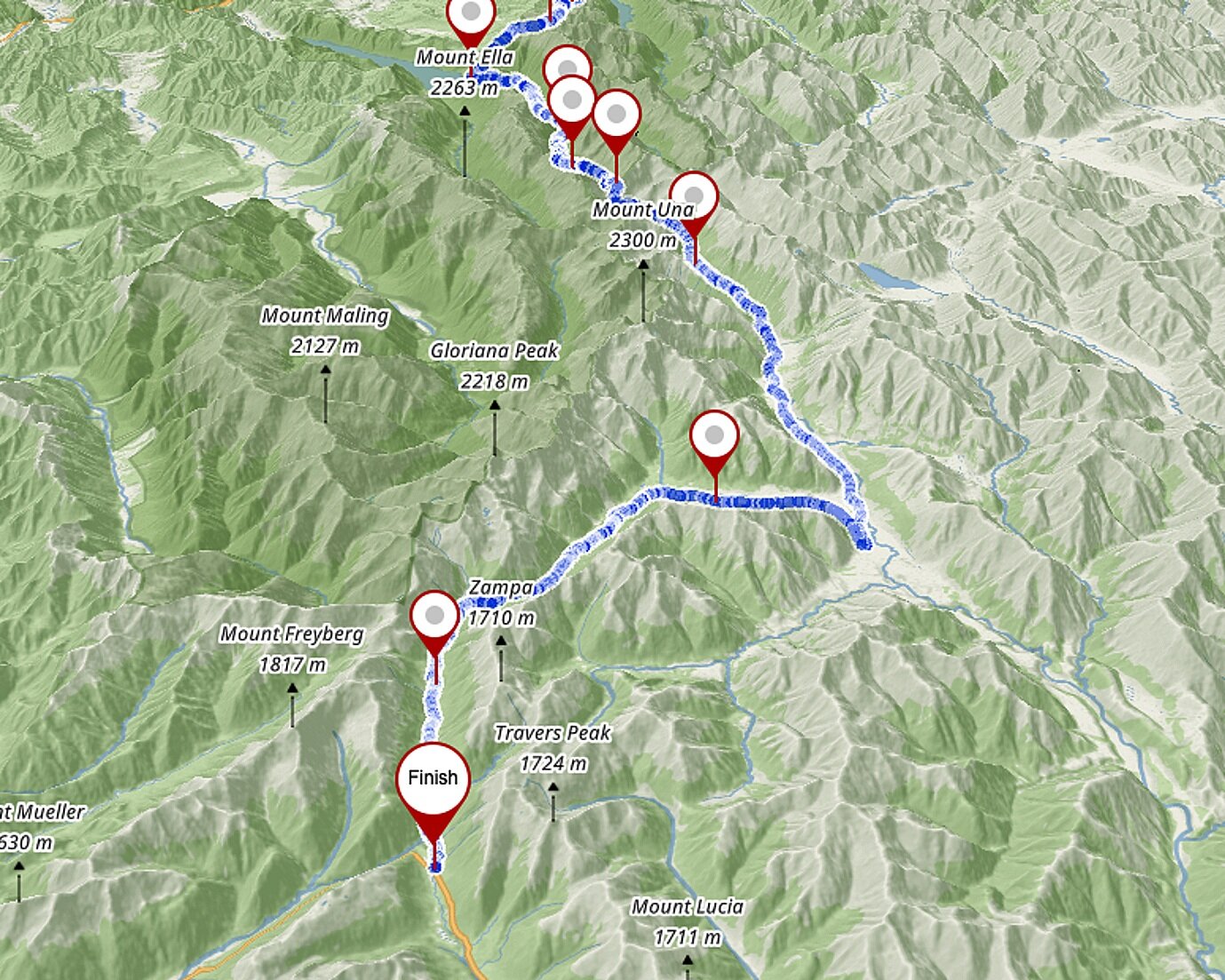
This walk is a combination of two circuit walks, the Travers-Sabine Circuit and the St James Walkway. These circuits on their own are fantastic experiences and make logistics extremely easy starting and finishing in more or less the same location. The Waiau pass however is what separates the two and by traversing this, you get to experience some of the best parts of both of these two tracks in one trip. There is a wide range of alternate routes and options to take for those who have more time on their hands or want to go at a slightly slower/faster pace, however the guide below consists of what we believe is the best option for most people and .

The scenery along the trail changes multiple times every day and it makes for such an engaging hike. Rocky mountain outcrops, Tussock covered hills, Moss covered beech forests, Alpine scrub and fields of gold wheat and more. I don’t think I’ve completed such a diverse track anywhere else.

Track condition
-Mostly very well taken care of trails, sign posted everywhere except for the Alpine pass
-Route finding over the Waiau pass is fairly easy in good weather by walking between bright blue poles, consider avoiding during low cloud/fog
-The St James side of the Waiau pass has many small stream crossings and one river crossing. These are all manageable in good weather with general river crossing practices

Optionals
-Angelus hut is the first stop on the way and I have no hesitation to say that this has to be one of the most beautiful Backcountry huts I’ve spent the night at in New Zealand. It can get busy during the summer so try your best to make this your first night as unfortunately this hut needs to be booked in advance.
-We recommend an extra day or two for those who want to relax a bit or are less physically able with suggestions in our guide below


Getting there

This track is a lengthy one way track which can make logistics a little tricky as you’ll be finishing about 2 hours drive away from your starting point. Most people (including people who are doing the Te Araroa trail) will walk north to south starting at St Arnaud and finishing at Lewis Pass. This is practical for the actual alpine pass as it is a safer direction to cross over it and it also means you’ll be walking the same direction as any others you might meet along the way.

Trail start location: Mt Robert Carpark, St Arnaud

Trail finish location: St James Walkway carpark, Lewis Pass


Accomodation

-Huts:

All but one night can be spent in spacious backcountry huts that generally sleep 20+ people.

-Camping:

The trail requires sleeping in a tent for at least one night of the journey and tents can be set up outside all huts

-Booking:

Note that the Angelus hut needs to be booked, however this hut can be skipped if you are unable to secure a spot and we give alternate options on our Day 1 summary

-Back-country hut pass:

Can be used for all nights except Angelus hut

What To Take

All the alpine areas in New Zealand are extremely unpredictable. There can be snow storms in the middle of summer and the Alpine areas of this track are very exposed making hikers vulnerable to any inclement weather. Safety locator beacons aren’t required outside of winter as the trail is popular and well formed but we strongly recommend you take one.

Summer Alpine | Example packing list

Spring / Autumn Alpine | Example packing list

Winter Hiking

Being an alpine crossing, the pass is not recommended for winter hiking however is it possible to make a smaller trip in this area by doing one of the separate circuits. Check in with the local Department of Conservation office before attempting and they can inform you of any track closures and avalanche danger.

Official Track Website And Other Links

Department of conservation website | Shuttle company for transport | Nelson Lakes National Park Weather

Elevation profile

 
Screen Shot 2019-12-26 at 5.20.15 PM.png
 

Trip Guide

DSC07096.jpg


Day 1 | Richmond Road Carpark to Angelus Hut

12km | 6 Hours

2-3hr
The first day starts with a steady climb with switchbacks taking you up above the tree line in about 1.5 hours. Emerging from the tree line the path is well formed heading over the Robert Ridge. A small shelter is encountered about 3 hours in which is a good place for a snack and should be used as a temporary shelter if the conditions aren’t suitable for the exposed ridges ahead.

2-3hr
Following this, the trail has gentle undulations some rocky terrain to navigate. Eventually the trail opens up to a dramatic outlook over lake Angelus and it is just a quick 30min descent to the hut


Lake Angelus Hut at sunrise


Day 2 | Angelus Hut to West Sabine Hut

18km | 7-9 Hours

4-5hours
Day 2 begins with a short ascent over rocky terrain heading towards Sabine Hut on the Mt Cedric Route. After reaching the highest point and beginning the descent, care needs to be taken navigating some tricky rocky outcrops. The rocky route finding then transitions into a formed track and is a good spot to stop and take in the Sabine River (Pictured). From here there are some gentle slopes through tussock covered hills before descending into tree cover where the track turns into a steep switchback descent under the tree line for about 2 hours until Sabine Hut is reached.

2-3 hours
After reaching the hut, the rest of the day is on a well formed track with a gentle gradient following the Sabine River up stream to reach West Sabine Hut. There are some good swimming holes along the way. For people with more time, sleeping at Sabine Hut with the following night at Blue Lake Hut is a good alternative and makes the third day a lot easier.


Day 2 is full of epic vistas like the one above


Day 3 | West Sabine Hut to Waiau Pass Campsite

22km | 7-9 Hours

The third day is the hardest but also the most rewarding of all. It’s important that the Waiau Pass is made before mid-afternoon when the winds pick up.

1.5-2 Hours
Start early and make your way along the Blue Lake Track towards the Blue Lake Hut. This is a gentle-moderate slope and a well formed track. The lake is worth a visit and a great place to stop for morning tea.

1.5-2 Hours
Fill your bottles up at Blue lake Hut before you make your way up the hill towards lake Constance. There is a well formed track which is easy to find. Make your way up the hill above the tree line and upon reaching the top the trail turns into route finding once again with the trail well defined most of the way. You need to take care climbing a scree slope on the west side of Lake Constance from which the trail undulates until a slippery descent towards on the other side of the lake.

2-3 Hours
The track is only partially formed from here on however is generally easy to follow in good conditions. Make your way towards a large scree slope due south. You’ll see a well poled route leading up the scree slope towards the Waiau Pass. It’s a tough 500m ascent to the Waiau pass traversing several scree slopes but is reasonably well formed most of the way.

2 Hours
The Waiau pass (Pictured) descent is a stark contrast to the ascent. Following the blue poles you just need to carefully make your way down a mixture of rocky outcrops and tussock covered slopes. It’s generally quite easy going for anyone of reasonable fitness and after an hour turns into a gentle slope through tussock and then lower to small scrubs. The Campsite is about 1.5-2 hours from where it flattens out next to the river. Don’t worry about missing it as the trail is well formed here and you’ll know when you’re there.


Moss covered forest floors are common in the forested sections of the trail


Day 4 | Waiau Pass Campsite to Christopher Hut

22km | 6-7 Hours

2 Hours
From here the trail continues towards the St James Walkway. The trail can be hard to follow at points and care just needs to be taken to follow all the orange markers. There are numerous small streams to walk through about ankle deep. Waiau Hut is reached and a good place to stop for a quick break.

4-5 Hours
From here, walk along the trail until you get to the St James Walkway junction. Again there are numerous small streams to walk through and one small section of the Waiau River to cross. If there has been recent heavy rainfalls ensure that you find a suitable portion of this river to cross. This day ends at Christopher hut which is 45 minutes West once the St James Walkway is reached.


Day 5 | Christopher Hut to Cannibal Gorge Hut

11km | 4-5 Hours

4-5 Hours
Following the St James Walkway towards Lewis pass, the remainder of the hike is easy to moderate gradients and follows a well formed track. Make your way to Cannibal Gorge Hut via Ada Pass Hut.


Day 6 | Cannibal Gorge Hut to St James Track Carpark

7km | 2-3 Hours

3 Hours
The final section of the track is mostly flat or downhill with a small uphill section at the end after crossing a bridge to Cannibal Gorge. 

At the road end, if transport hasn’t been pre arranged hitchhike or walk to West to get to Maruia Springs where you can organise to board the daily bus through Lewis Pass or a shuttle bus. Best to get here as early as possible.


Cannibal Gorge Hut